Saturday, November 27, 2010

Muthodi-Kemmanagundi-Hebbe Falls

 
BHADRA WILDLIFE SANCTUARY (MUTHODI)-KEMMANAGUNDI-HEBBE FALLS- KALHATHGIRI FALLS TOUR – NOVEMBER 2010

I had been to Bhadra Wildlife Sanctuary, Muthodi along with my fellow Photographers Friends Satish H, Sateesh.N (Finance Dept, Vidhana Soudha) and myself and also accompanied by Sudhakar, Nagendra (Superintendent, BHS) and Umesh (RGUHS) from 24th November to 26th November 2010,


DAY 01 : 24th November 2010
:

Left early morning from Bangalore, all the friends met at Sri Sudarshan Residence along with his Innova we moved towards Kunigal via Magadi had a beautiful breakfast (idli Vade, and famous Kali Dosa) at Hotel Parimala, Kunigal and from there we moved towards Chikamaglur and met Vishwanath Friend Sri Satish from Chikamagalur had Lunch at Food Palace and bought some Coffee, Tea Powder and Vegetables, reached Bhadra Wildlife Sanctuary by 2-30 pm met Shashi (Forest Guard) and stayed at Sighe Khan Estate Guest House and we had a safari at 4-30 pm with Dept Vehicle, we had been to Big Teak Tree

Brief Info on Big Teak Tree

Bombax ceiba or Boorugada mara is seen en route to Mavinahalla in Lakkavalli range. The tree is more than 200 years old and has a 32 feet trunk. It provides food for squirrels during summer.

Terminalia Tomentosa or Matthi mara is found in Balegundikere in Thanigebailu. The tree has 22 feet trunk and is 300 years old, says environmentalists.

Teak wood is found en route to Kesave from Muthodi. The tree is 400 years old and has 17 feet trunk.


as it was heavy rained two days back all the route was very horrible even 4W Drive was not so easy to travel, we had struck down at few places in the middle of the jungle and our dept vehicle also strucked and we had a experience of that in this trip, finally we came back to Nature Camp and had tea and having dinner at Sighe Khan Guest House and we gone with the sleep


Brief Info Bhadra Wildlife Sanctuary
The Bhadra Wildlife Sanctuary in the Chickmagalur and Shimoga Districts, is one of the most fascinating sanctuaries. Bhadra wild llife Sanctuary is located about 38 Kms North-West of Chikmagalur.


Bhadra Wildlife Sanctuary is popularly known as Muthodi Wildlife Sanctuary, housing some of the great wildlife reserve like the most endangered species- the tiger. The sanctuary is surrounded by Mullaianagiri, Hebbegiri, Gangegiri and Bababudangiri hills and has the tributaries of the Bhadra river flowing through it.

A diverse range of wildlife is found in the sanctuary like bison (Gaur), Elephants, Tiger, Leopard, Sambar, Chital spotted deer, Boar, Porcupine, Muntjac, birds like the Peacock, Parrot, Partridge, Pigeon, Munia and Bee eaters, and reptiles such as King Cobras and Indian Rock Pythons. More than 250 species of bird life, many of which are widespread to the Western Ghats, are spotted here. Marsh crocodile, flying lizard, monitor lizard and different kinds of snakes are some of the reptiles found here. October to February is best time to visit Bhadra Wildlife Sanctuary.

 
Best time to visit: November to March

Day 02 : 25th November 2010After having morning Tea and bath, we trekked from Sighe Khan Guest House to Nature Camp (3 Kms) and glimpses of backstream around Nature Camp, had breakfast, met RFO and Forest Official and thanked them for their co-operation and moved towards Kemmanagundi, enroute we had a fine pictureseque landscapes, enroute we had been Seethalayana Mutt and had darshan over there
Seethalaya Mutt Temple, Mullayanigir


Landscape near Seethalaya Mutt Temple
 and reached kemmanagundi at 2-30 we stayed at Forest Dept Guest House, (nice one) and Meti was waiting for us, we had a lunch over there and hired a Jeep for Hebbe Falls, (Horrible Jeep and Ride-No Break,Nothing-Seniority wise we got that jeep) and driver was quite experienced in that route safely he landed us near the gate of Hebbe Falls (RANSH ESTATE), and we had to trek about 1-2 kms to reach Hebbe Falls, had good photographs over there
Aerial view of kemmanagudi from Raj Bhavan

Kemmannugundi Kemmannugundi (Kannada: ಕೆಮ್ಮಣ್ಣುಗುಂಡಿ) is a hill station in Tarikere taluk of Chikkamagaluru district in the state of Karnataka, India. It is located at a height of 1434m above sea level. This was the summer retreat of Krishnaraja Wodeyar IV and as a mark of respect to the king, it is also known as Sri Krishnarajendra Hill Station. Ringed by the Baba Budan Giri Range and blessed with silver cascades, mountain streams, and lush vegetation, Kemmangundi’s beautifully laid-out ornamental gardens and enchanting mountains and valleys views are a treat to the eye. The spectacular sunset view from the Raj Bhavan is a photographer’s delight. For the adventurous at heart, Kemmangundi offers many peaks to scale and intricate jungle paths to explore


Origin of name
Kemmannugundi (or Kemmannagundi) derives its name from three Kannada words - Kempu (red), mannu (soil) and gundi (pit) and means a place with red soil.

Transport
Road
Kemmannugundi is about 53 km from Chikkamagaluru and 20 km from Lingadahalli by road. The nearest National Highways, NH-206 or NH-48, connect to Bangalore. There is another route to reach which is via Mullayanagiri, a scenic drive.
Rail
The nearest railway station is 35 km away at Tarikere.
Air
The nearest airports are at Mangalore (150 km) and Bangalore.


History

Kemmannugundi was established as the summer retreat of Krishnaraja Wodeyar IV. He later donated this resort to the Government of Karnataka. The Horticultural Department of Karnataka now develops and maintains the resort and its surroundings.

Raj Bhavan


Raj Bhavan is a guest house located in Kemmannugundi and offers a spectacular view of the surrounding hills. The view of the sunset from Raj Bhavan is something to be cherished.


Z point


enroute to Z Point
 Z point is a vantage point at Kemmangundi and can be reached by a steep uphill trek of about 45 mins. from Raj Bhavan and is another favourite place of people who want to view a spectacular sunrise . As it is a walk beware of slippery roads and snakes and also visit shanthi falls nar kemmangundi

Shanthi Falls
Shanthi Falls enroute Z Point
Rose garden
Rose garden, as the name suggests is a garden of roses maintained by the Horticultural Department. Various varieties of roses are cultivated here.

Hebbe Falls


A downhill trek of about 8 km from Raj Bhavan takes one to Hebbe Falls where water streams down from a height of 168 meters in two stages to form Dodda Hebbe (Big Falls) and Chikka Hebbe (Small Falls). Jeeps are available from one particular point to Hebbe falls and they charge around 700/- to 1200/- (for up and down depending on no of persons). We can take a trek if you have enough time.

Hebbe Falls, Near Kemmanagundi

Sateesh & Umesh near Hebbe Falls
Another View of Hebbe Falls, Kemmanagundi


Kallathi Falls

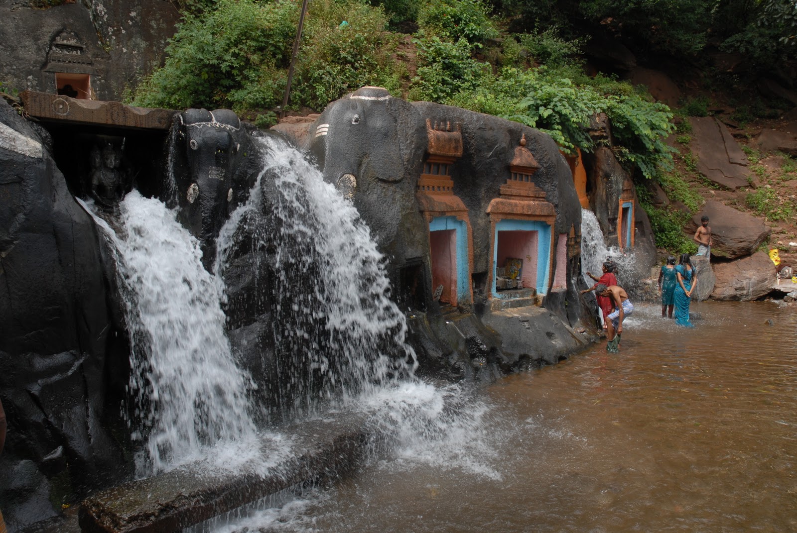
Kallathi falls is about 10 km. from Kemmangundi. On the road from Kemmangundi to Tarikere, a deviation takes one to Kallathi falls. It is also known as Kallathigiri falls and Kalahasthi falls. Water cascades from a height of 122 metres and the temple here is attributed to times of the Vijayanagar empire. According to a local legend, this place is associated with the Hindu sage, Agastya

Kalhatti Falls or Kalahasti Falls is located at Kallattipura in Chikmagalur district of Karnataka. The waterfall is only 10 kilometers away from Kemmangundi hill station. It offers an excellent view of the cascading water from the Chandra Drona Hill from 122 meters (400 ft) above in front of the Veerabhadreshwara Temple dedicated to Lord Shiva.


The Legend
Legends say that sage Agastya had prayed for a long time in this place.The Veerabhadra temple is supposed to be built in the Vijayanagar times. The temple is with three stone carvings of three elephants at the entrance. Water cascade water over these elephants and devotees believes that these waters have the power to cure diseases.


An annual fair of Lord Veerabhadra is held here for three day during March/April which attracts pilgrims from many parts of the state.


Its also hot spot among the trekkers who carry out their trekking exercises on the adjoining hills and mountains. Trekkers climbing along the mountainous terrains enjoy the picturesque view. With base in Tarikere which is 35 km from Kemmangundi, trekkers climb the hill slopes to enjoy the panoramic view of the verdant valleys below.


Location

Kalhatti Falls is located one hour from Birur (Birur - Kadur Taluk in Chikmagalur District). Birur is near Kadur, between Arsikere in Hassan Dist and Bhadravathi in Shimoga Dist. From Birur, Kalhatti is accessible through Lingadahalli.


Distances from Kalhatti Falls

1. Kemmangundi: 10 km
 2. Bangalore: 245 km
3. Mangalore: 180 km


How to reach
• Nearest Railway Station: Birur
• Nearest Airport: Mangalore
• Nearest International airport: Mangalore


The route from Bangalore is through Tumkur - Tiptur - Arsikere - Kadur - Birur on NH206. The road from Birur to Lingadahalli is about 15 km from there, there is a fork whose left arm goes to Santaveri and continues towards Chikmagalur and the right arm goes towards Kalhatti falls and Kemmangundi.

How to get there: Birur is a junction well connected on the Bangalore-Shimoga, Bangalore-Kolhapur, Bangalore-Hubli or Yeshwantpur-Vasco routes. The Shimoga Express leaves Bangalore at 2310 and reaches Birur at an unearthly hour of 0315. Buses from Birur towards Lingadahalli are at 0545, 0630 and quite regularly after that. These buses take about 30 mins. You can hire private vehicles to take you till Kalhattigiri (another 30 min. ride on road)from where you can begin the trek.

Accommodation:
Kalathagiri Guest House, Horticulture
Accommodations are available at Horticulture Guest House, Kalhatti falls

Glimpses of Tour Photographs


Monday, November 15, 2010

Manchinbele Reservoir

Manchinbele Reservoir

Location: Manchinbele Lake /Reservoir / Dam

Date: Nov 14th 2010

I had been to Machinebele Dam along with my fellow photographers Satish H, Chandrashekar and Myself on 14th Nov 2010

To get there:  From Mysore road take a right turn immediately after Raja Rajeshwari Dental college and much before Bidadi. Go past the tourist spot Big Banyan tree or Dodda Alladha Mara. Ask for Manchinbele along the way. There are some yellow direction boards posted when you get near.


Distance: About 30kms from Bangalore until the turn off from Mysore road. Then 10-15kms to reach the reservoir.


Facilities: Not much near the reservoir. There are plenty of shops around Big Banyan tree.
Purple Sun Bird

Sunday, November 14, 2010

Bheemeshwari-Muthathi

BHEEMESHWARI AND MUTHATHI

State: Karnataka 
District: Mandya
Famous for/as: Trekking, Rafting
Languages: Kannada
Best Season: Aug - Feb
Weather: Summer 22-40°C, Winter 10-32°C
Altitude: 800-1200 m
Pincode: 560001
STD code: 08933

I had been to the Bheemeshwari along with my fellow friends -
the Team
Vishwanath (Photographs of this Place)
Myself
Ganesh and
Ishwar

and we met a good team at Kanakpura Rotarians
Satish (Kannada Prabha Correspondent)
Arasu, Devegowda, Maiya, Chandru 
With the help Sri Satish, we had a stay at Bheemeshwari Nature Camp (Forest Dept)


Cauvery River, Bheemeshwari

This place, which is located about 100 km away from Bangalore in the district of Mandya, is fast becoming a major tourist attraction. It is situated between Barachukki and Gaganachukki and Mekedatu falls. This is a perfect place for the nature lover.

There is abundant natural scenery in this place together with ample fishing facilities. In fact, the place is known as the fishing destination of the region. Tourists can see a large number of animals in this region including leopards, jackals, crocodiles, deer, wild boars and plenty of exotic birds.

Another View of Cauvery River
It makes for an excellent trekking spot. This is also home to the famous gaming fish - The Mahseer. This is the perfect place if you want to enjoy the beauty of nature.

Tourists can lodge in at the numerous cottages that are scattered in the region. These provide a cozy atmosphere and are a good place to stay while in Bheemeshwari.
Forest Dept Guest House, Bheemeshwari
Tourists can go for boat rides on the river Cauvery. These rides would take the tourists through some of the most beautiful places in the region. They would glide through forests and might even spot animals and birds. Boat ride amidst the breath taking natural scenery is sure to take the breath away.


Forest Dept
Deputy conservator of forests,

Cauvery Wildlife Division, Kanakapura
E-mail: dcfcauverywildlife@mysterytrails.com
Phone: 080-7522537

for Trekking in and around Bheemeshwari, please do visit
http://mysterytrails.com/BheemeshwariToChellurehill.htm


Muthathi Anjaneya Temple

Muthatharaya Anjaneya Temple, Muthathi
Muthathi is a small village on the bank of Kaveri. The road to Muthathi runs along the river, and you can stop at places to spend time on the river bank or dip your feet in shallow waters. The village and the approach road are within the boundary of Cauvery Wildlife Sanctuary.

Expect to sight some wildlife if you are lucky, which includes chital, sambar deer and even elephants.Cauvery Wildlife Sanctuary is home to rare and endemic grizzled giant squirrels. The region is also rich in bird life. Take Kanakapura road out of Bangalore till you get to Satanur. Turn left at Satanur and drive for another 30 minutes to get to Muthathi. There is no food and accommodation avaialable at Muthathi. Pack your own food and plan to return by the end of the day.


Thursday, October 21, 2010

EXPEDITION TO MOUNT EVEREST BASE CAMP-1996

MOUNT EVEREST
I HAD BEEN TO MOUNT EVEREST BASE CAMP TREKKING EXPEDITION IN THE YEAR 1996
(OLD ARCHIVE ARTICLE OF MINE)

The Team Members
H Rajakumar
(Team Leader)

N Sateesh
(Deputy Team Leader)

S Viswanath
Ananth Kaskar
NJ Gunaprakash
Anna Durai

Date From 10-05-1996 to 09-06-1996

Day I Jiri to Deorali
Day II Deorali to Sete
Day III Sete to Junbesi
Day IV Junbesi to Nunthala
Day V Nunthala to Bupsa
Day VI Bupsa to Chaurikharka
Day VII Chaurikharka to Namche Bazaar
Day VIII Namche Bazaar to Thyangboche
Day IX Thyangboche to Dugla
Day X Dugla to Goraksheep
Day XI Goraksheep to Kalapathar
Day Kalapathar to Thyangboche
Day XII Thyangboche to Namche Bazaar
Day XIII Namche Bazaar to Cheplung
Day XIV Cheplung to Lukla
Day XV Lukla to Kathmandu

DAY I JIRI to DEORALI
Early in the morning started trek to reach BHUNDAR in mind. From Jiri we followed a trail leading up the east side of the valley, passed KHARUBA pass at an eight of 2713m. From the pass we descended towards YELUNG KHOLA – crosses suspension bridge over KHIMTI KHOLA to reach SHIVALAYA(1,800m) – Had Lunch – All along the trek we came across some rhododendron forests, specular feature of this trek. North of the Mohabir village through forest we had an fine view of side streams with windmills, reached BULDAR PASS (2713m)-Maniwalls and prayers flags, an uphill task to reach DEORALI at 5.30 PM rain started – decided to stay at Deorali.

DAY II DEORALI to SETE


Left early morning at 5.30 AM – an downhill through a sylvan forest of oak and rhododendron, passing large religious shrine into a beautiful vally that truly marks the start of SHERPA country. The village of CHYANMGA (BHANDAR). We met one local school teacher he had taken some initiative some projects including power generation to his house through the following stream which confluence with HIM GANGA river. The village of Bhandar we found a mixture of TAMANGS and MEWERS – descended through forest again with terraces to reach PHEDI a CHETRI village – crossed suspension bridge walked along river HIM GANGA to reach KINJA (1,634m). In Kinja we found school, a police checkpost and dispensary. Again an uphill steep climb from the Kinja follows a trail with oak trees and rhododendron forest to reach SETE (2,575m) at 5.40 PM – Weather was very chilled The village SETE is covered with clouds as we had to stay.

DAY III SETE to JUNBESI


Left same timings – an uphill route to DAKCHU –view of Number Range – reached KATHA BASAUNI – This day we had to cross LAMJURA Pass (3530m) through uphill task of oak and greeny coloured these along with pine trees, trail follows the line of ridge passing several houses. Pass marks entry into the SOLU KHUMBU region. We had a feel, sense of pleasure when we reached LAMJURA pass (Gateway to Mountains) – weather was getting bad decided to descend to reach TAK TOR through a thick forest of fixed fir to reach AM Lodge one of early batch friend Mr. GP Sherpa of TAK TOR – Had lunch – As soon as we left the TAK TOR heavy rain started on the route to junbesi downhill reach camp JUNBESI at 4.30 PM – because of offseason we couldn’t get the accommodation because all the lodges in junbesi village were closed finally we got one lodge and stayed JUNBESI – (2575M) – A large Sherpa village with its monastery and school built by Sir Edmund Hillary. We can have a view of JUNBESI KHOLA to the south of NUMBER Range (6959m).

DAY IV JUNBESI to MANIDINGMA (Nunthala)

Crossing a small bridges at 5.30 AM – an uphill upto PHURTYING – Valley of Beni Khola – reached Solung plain trek upto Ringmo (2,005m) – a steep climb upto the lank of Kenche Danda till TRAKSHINDU pass – had lunch at trakshindu village- a Gompa (Monastery) 50 years old set up in 1946 and a school downhill to rach Nunthala (Manidingma).


DAY V MANIDINGMA to BUPSA


Downhill through thick forest and terraces – view of langur monkeys – crossed suspension bridge across river DUD KOSHI – climbed and uphill to Juving (A RAI Settlement) path meanders through stands of bamboo near the house – trail continued to reach KHARI KHOLA – Had Lunch-predominentally a village of of Sherpa and Magyar inhabitants. An uphill and tough steep climb to reach BUPSA – in the last stretch to reach our camp a landslide occurred, village people are clearing the place to the use of trekkers – met UK National – visited old monastery

DAY VI BUPSA to CHAURI KHARKA

Left BUPSA to reach Phakding – a stream and thick forest with a mixture of oak, pine bamboo and pirch-trail continued and reached Puyivan (2,800m) slowly rising on the flank of the Sebuk Dhanda to Chutok La – pass accessed to Hinku Valley – a descending nearly 600-700 mts to reach SURKYA (2,300m) – Rain started heavily while getting down to SURKYA – Had lunch-minor injuries to all in the rainshed area- towards north we moved on the main trail which traverses a gorge with a waterfall- again rain started heavily before we reached CHAURI KHARKA (2,652m) and decided to halt at this point because of the bad weather and all the members of the team were tired and exhausted.

DAY VII CHAURI KHARKA to NAMCHE BAZAAR

Reached Cheplung all along the river Dudh Koshi – the trail for Lukla joins here from Chaurikharka and them we moved to Phakding-plain trek crossing rickety, cantilevr bridge – a fine view of TAMSHERKU peak. Had breakfast – reach Tak tok- a gradually uphill climb not so steep to reach Benkar- to reach Namche the trail continues to a Benkar and eventually cross back to the east bank on a makeshift cantilever log bridge and new suspension bridge built by HMG under the Swiss – then trail continued upto the east bank crossing again Dudhkoshi by a large Sagarmatha National Park – reached Jorsale had lunch – very tough climb starts to reach Namche crossed again a wooden bridge joining another river along with Dudhkoshi- tiresome trek to reach NAMCHE (3446m). Hired Sleeping Bag, Jackets and other needful for higher camp.
DAY VIII NAMCHE to THYANGBOCHE
Path forks left from the Sagarmatha National Park- north east of Imja Khola – valley is heavy deforested and grazed with cultivation – open hillside covered with somewhat sweet smelling dwarf rhodendrons, alpine trees and berberies – reached KYANJUMA – we had a iew of TAMSHERKU, Kusum Kanguru and Kangtage way to striking form of sitting phantom – MOUNT AMA DABLAM – the mountain is at her benign, snding down the ridges like welcoming arms. Crossed a small wooden bridge below the river – we descended through past large boulders- crossed stream dn meet the path – reached Sanasa – the place to pass to peak GOKYO – then continued through all along the pine and past forest nursery funded by Sir Edmund Hillary Foundation under SPCC – crossed a small bridge near Phungi Tanga – n army base to protect Sagarmatha national Park – met jawans nearly 500-600 m steep climb through a marvelous and fantastic woods of pine, juniper and fir with rhododendron – reached THYNAGBOCHE(3875m).

THYANGBOCHE – There is a Monastery fully surrounded by the mountain peaks and we can view the Mount Everest from this place along with Kalapathar “only” and Mount AMA Dablam with a panoram extends from CHOLATSE and Tawache to massive wall of Lhotse and Nuptse with peeping EVEREST on back-

Monastery: The Gompa was destroyed by earthquake in 1934 and then in 1979 it was again destroyed by fire now at present it was rebuilting with the help of WWF and other individual donors.
DAY IX THYANGBOCHE to DUGHLA

Trail pass down the stream and descend through a haunting wood of juniper curly barked silver birch – we had a view of Musked Deers, mountain goats and pheasants continued our trail through an opening door arch to small notch between large builders- divides path to Pangboche- here a 300 years old monastery had a YETI SCALP then we moved after climbing an uphill and downhill and plain trek to reach Pheriche crossing a small wooden bridge it was very windy – view of Mount Lobjue East – a main street on both side with stonewalls enclosing houses and lodges. It was the last Sherpa village and one large building where HRA exists (HIMALAYAN RESCUE ASSOCIATION) – we decided to visit to know about AMS and other mountain problems, it was winding up the camp there because it was the end of the season. It is a domination of Tawache and Cholatse – extra day is necessary for those who couldn’t get acclimitised for mountain weather to reach higher camps. –trail leads of valley on both sides with snow cap mountains – terminal moraine at the snout of the rubble covered KHUMBU Glacier but it was fully rocky moved all along the rock path to reach DUGHLA.

DAY X DUGLHA to GORAKSHEEP
Trail levels out and chortens (samadhi’s) stands an uphill climb to have scene of memorial to sherpa and other mountaineer killed on Everest –climbed along lateral rocky path again of Khumbu Glacier and reached Lobuje (4887m) – only few hotels were operating because of unseason. Had breakfast – a best and ideal place to climb LOBUJE EAST weather was fine spent nearly one hour in Lobuje – amid huge moraines and grand peaks-last habitation before Base Camp of Everest – then continued our trek with rocky path while we are moved towards Goraksheep – some of HRA aids and Sherpas were bringing one dead body from Everest Base Camp to dig in Lobuje – we are came to know the disaster in Mount Everest that renowed climbers like Scott Fischer of US and Rob Hall of New Zealand and others has been killed after summiting their expediton. Some Expedition teams including from ITBP (Indo – Tibet Border Police) climbers have also died during their descent – we reached Goraksheep at 2.30 a slight headache appeared to all and then acclimitised and decided to summit Kalapathar Next day – the Grand Finale.

DAY XI GORAKSHEEP-KALAPATHAR-THYANGBOCHE

It was came to know that since two days back there is no view of Mount Everest from Kalapathar, the hotel boy has informed to leave at 7.30 AM but we decided to leave at 5.30 AM in the morning as soon as we are climbing Kalapathar peak we got tired and exhausted because lack of oxygen we had 5 minutes walk and 10 minutes rest. Finally reached Kalapathar at 7.00 we had a nice view of Mount Everest took photographs as soon as we are getting down the clouds are moving in valley as if we are in KAILAS PARVATHA. As time is moving EVEREST is covered with full clouds not even our team members are visible on the Kalapathar – we came back very fastly, because we had in mind of getting weather even worse it was very chilled. Had breakfast –left Goraksheep at 10.30 am – reached Pheriche at 12.20 pm had lunch and reached Thyangboche at 6.00 pm.

DAY XII THYANGBOCHE to NAMCHE

DAY XIII NAMCHE to CHEPLUNG

DAY XIV CHEPLUNG to LUKLA

DAY XV LUKLA to KATHMANDU (by Air)


Sunday, October 10, 2010

ಕೋಲಾರ ಪ್ರವಾಸ

ಕೋಲಾರ ಪ್ರವಾಸ

I had been to the Kolar District  on 09th Oct and 10th Oct and I have visited the following tourist attractions  in and around KOLAR


The TEAM
Myself
Sateesh N (Finance Dept, Vidhana Soudha)
Umesh UG
Ganesh (State YHAI Secretary)
Eshwar and
Aswath (Kolar Dist YHAI President)

Date : 08th Oct 2010:
Left Bangalore by 11-45 ame enroute had lunch at Jai Maruthi  Dhaba and Reached Kolar by 2-30 pm and we stayed at Central Lodge (Courtesy Mr. Ganesh) and we had been to the Seven Hills, visited Neelakanteshware Temple (Old ruined) with lot of caves all along the way and visited Shivaganga where Adima - The Arche for the Lost Wisdom of our Past (A Dalit Resource Centre With a Difference) for details of the organisation please go thro http://www.adima.org/Aboutus.html and met Jinke Ramaiah, had discussion with him about his organisation, for any queries please do contact: http://www.adima.org/Contactus.html   and in the evening we visited local Ganesha Festival in the Kolar Town

Date 09th Oct 2010
Morning at 6-30 am we left towards Antaragange and had bath and had a darshan of kashi vishweshwara and left by 8-30 am and had breakfast at local hotel in Kolar visited Someshwara temple, Kolaramma Temple, Shankaramutt and moved towards Chikolli enroute to Chintamani we visited Kailasa Giri, Alangiri and Kaiwara and back to Bangalore by 08-30pm heavy rains


These are the few information about Kolar Dist and Photographs

 ಕೋಲಾರ

ಕೋಲಾರ ಕರ್ನಾಟಕ ರಾಜ್ಯದ ಒ೦ದು ಜಿಲ್ಲೆ.ಇಲ್ಲಿರುವ ಚಿನ್ನದ ಗಣಿಗಳು ಮತ್ತು ಚಿನ್ನದ ಗಣಿಗಾರಿಕೆಗೆ ಕೋಲಾರ ಜಿಲ್ಲೆ ಪ್ರಸಿದ್ಧ. ಕೋಲಾರ ನಗರ ಈ ಜಿಲ್ಲೆಯ ಕೇಂದ್ರಸ್ಥಾನ.ಕೋಲಾರ ಜಿಲ್ಲೆಯು ಆಂಧ್ರಪ್ರದೇಶ ಮತ್ತು ತಮಿಳುನಾಡು ರಾಜ್ಯಗಳ ಗಡಿಗೆ ಹೊಂದಿಕೊಂಡಿದೆ.

ಕೋಲಾರ ಗಂಗರ ರಾಜಧಾನಿಯಾಗಿತ್ತು ಇದನ್ನು ಮೊದಲು ಕುವಲಾಲಪುರ ಅಂತಲೂ ಕರೆಯುತ್ತಿದ್ದರು.ಕಾಲ ಕ್ರಮೇಣ ಕೋಲಾರವಾಯಿತು. ಗಂಗರು ಕಟ್ಟಿಸಿದಂತ ಹಲವಾರು ಸ್ಥಳಗಳು ಕೋಲಾರದಲ್ಲಿ ಮತ್ತು ಕೋಲಾರ ಜಿಲ್ಲೆಯಲ್ಲಿವೆ ಅದರಲ್ಲೂ ಮುಖ್ಯವಾಗಿ ಗಂಗರು ಕಟ್ಟಿಸಿದ ಕೋಲಾರಮ್ಮ ದೇವಾಲಯ ಜಿಲ್ಲೆಯಲ್ಲಿಯೆ ಪ್ರಸಿದ್ದಿಯನ್ನು ಪಡೆದಿದೆ.

ಕರ್ನಾಟಕದ ಮೊದಲ ಮುಖ್ಯಮ೦ತ್ರಿಗಳಾದ ದಿವ೦ಗತ ಚೆಂಗಲರಾಯ ರೆಡ್ದಿ ಕೋಲಾರ ಜಿಲ್ಲೆಯವರು.ಮೈಸೂರು ಸ೦ಸ್ಥಾನದ ದಿವಾನರಾಗಿದ್ದ ಹಾಗೂ ಕರ್ನಾಟಕದ ಅತಿ ಪ್ರಸಿದ್ಧ ವ್ಯಕ್ತಿಗಳಲ್ಲಿ ಒಬ್ಬರಾದ ಸರ್. ಎ೦ ವಿಶ್ವೇಶ್ವರಯ್ಯ ನವರು ಸಹ ಕೋಲಾರ ಜಿಲ್ಲೆಯವರು.

ಚಿತ್ರ ನಟಿ ದಿ: ಸೌಂದರ್ಯ ಮತ್ತು "ಮಂಕು ತಿಮ್ಮನ ಕಗ್ಗ " ದ ಕರ್ತೃ ಶ್ರೀಯುತ ಡಿ. ವಿ. ಗುಂಡಪ್ಪ ನವರು ಮುಳಬಾಗಿಲಿನವರು ಮಾಜಿ ಸಚಿವ ಶ್ರೀ ರಮೇಶ್ ಕುಮಾರ್ ಶ್ರೀನಿವಾಸಪುರದವರು ಜ್ಞಾನ ಪೀಠ ಪ್ರಶಸ್ತಿ ಪುರಸ್ಕೃತ " ಮಾಸ್ತಿ ಕನ್ನಡದ ಆಸ್ತಿ " ವೆಂಕಟೇಶ ಅಯ್ಯಂಗಾರ್ ಮಾಲೂರು ತಾಲ್ಲೂಕಿನ ಮಾಸ್ತಿಯವರು ಕರ್ನಾಟಕ ಮೊತ್ತ ಮೊದಲ ಸಮುದಾಯ ರೇಡಿಯೋ ಕೇಂದ್ರ ಪ್ರಾಂರಂಭವಾದದ್ದು ಕೋಲಾರ ಜಿಲ್ಲೆ, ಬಂಗಾರಪೇಟೆ ತಾಲ್ಲೂಕಿನ ಬೂದಿಕೋಟೆಯಲ್ಲಿ ಇದು ಅಂತರ್ ರಾಷ್ಟ್ರೀಯ ಮಟ್ಟದಲ್ಲಿ ಹೆಸರು ಪಡೆದಿದ್ದು ಕೆಲವೇ ದಿನದಲ್ಲಿ ತರಂಗಾಂತರದಲ್ಲಿ ಕಾರ್ಯಕ್ರಮಗಳು ಪ್ರಸಾರವಾಗಲಿದೆ.  ಜೊತೆಗೆ ಕೋಲಾರ ಜಿಲ್ಲೆಯ ಮಿನಿ ಕೆ.ಆರ್.ಎಸ್ ಎಂದೇ ಪ್ರಸಿದ್ದಿಯಾದ ಮಾರ್ಕಂಡೇಯ ಕೆರೆ ಸಹ ಇದೆ. ಮೈಸೂರು ಹುಲಿ ಎಂದು ಪ್ರಸಿದ್ದಿಯಾದ ಟಿಪ್ಪುವಿನ ತಂದೆ ಹೈದರ್ ಆಲಿ ಜನಿಸಿದ್ದು ಸಹ ಇಲ್ಲಿಯೇ.

ಕೋಲಾರ ಜಿಲ್ಲೆಯಲ್ಲಿರುವ ಕೆಲವು ಚಾರಿತ್ರಿಕ ಸ್ಥಳಗಳೆ೦ದರೆ ಚಿನ್ನದ ಗಣಿ (ಕೆ.ಜಿ.ಎಫ್), ಮುಳಬಾಗಿಲು, ಬ೦ಗಾರು ತಿರುಪತಿ, ಕೋಟಿಲಿ೦ಗೇಶ್ವರ, ಅ೦ತರಗ೦ಗೆ, ಮಾರ್ಕ೦ಡೇಯ ಪರ್ವತ, ಸೋಮೇಶ್ವರ ದೇವಸ್ಥಾನ, ಗ೦ಗ ವ೦ಶದ ಅರಸರು ಕಟ್ಟಿಸಿದ ಕೋಲಾರಮ್ಮನ ದೇವಸ್ಥಾನ , ಕುರುಡುಮಲೆ, ಆವಣಿ, ಮುರುಗಮಲ್ಲ ದರ್ಗ(ಚಿಂತಾಮಣಿ), ನಂದಿ ಬೆಟ್ಟ (ಈಗ ಚಿಕ್ಕಬಳ್ಳಾಪುರ ಜಿಲ್ಲೆಗೆ ಸೇರಿದೆ), ವಿಧುರಾಶ್ವತ್ಥ (ಗೌರಿಬಿದನೂರು)

ಕೋಲಾರ ಜಿಲ್ಲೆಯ ಪ್ರಮುಖ ಭಾಷೆ ಕನ್ನಡ.ಇಲ್ಲಿ ಚಾಲ್ತಿಯಲ್ಲಿರುವ ಇತರ ಭಾಷೆಗಳೆ೦ದರೆ ತೆಲುಗು,ತಮಿಳು ಮತ್ತು ಉರ್ದು.

ಕೋಲಾರ ಜಿಲ್ಲೆಯ ಮುಖ್ಯ ಕಸುಬುಗಳೆ೦ದರೆ ಕೃಷಿ, ಪಶು ಸಾಕಾಣಿಕೆ ಹಾಗೂ ರೇಷ್ಮೆ ಉದ್ಯಮ.

Location: Kolar is located at a distance of about 68 kilometres from Bangalore. It lies in the eastern part of Karnataka. It is situated on the Bangalore to Chennai National highway (NH-4). Kolar is also known for its fortresses and temples


Nearest Town: Kolar.
Route: From Bangalore,
From Kolar bus stand, take a left and go 4 km to reach Antaragange.


Air: The nearest airport is Bangalore airport.Rail: The nearest railway junction is Bangarpet at a distance of about 15 km.
Transportation: Government buses ply on regular basis daily from Bangalore.
All these places are a days trip from Bangalore

NEELAKANTESHWARA TEMPLE
On the foothills of the Antaragange near the Theralli, we can find this temples


Antaragange
 
Antara Gange is a mountain situated in the Shathashrunga mountain range in the southeastern portion of the Indian state of Karnataka. Antara Gange literally means "Ganges from deep" in Kannada. It is about two miles from the town of Kolar and seventy kilometers from Bangalore. Antara Gange is famous for the temple situated on the mountain. In the temple is a pond which gets a continuous flow of underground water from the mouth of a Basava (stone bull). There is a steep, narrow path to the top of the mountain. There are seven villages on this mountain, including Therhalli. The mountain contains volcanic rocks and lot of caves around.


Location: Kolar is located at a distance of about 68 kilometres from Bangalore. It lies in the eastern part of Karnataka. It is situated on the Bangalore to Chennai National highway (NH-4). Kolar is also known for its fortresses and temples
Nearest Town: Kolar.

Route: From Bangalore,
From Kolar bus stand, take a left and go 4 km to reach Antaragange.


A place in Kolar district full of hillocks with numerous bouldering opportunities.This place is 4kms from the Kolar busstand. The other attraction of this place are few Temples where there is no end to the water streaming out of the barren rocky area. And Near one of the temple one can also find a small park kind of arrangement where a few deer are present. Though nowadays the top of the hillocks can be reached by a newly constructed road. One has to take deviation before reaching Kolar for this road. This place Antaragange probably got it name by the water found in large quantity on the rocky hillocks. These hillocks are also good source of bouldering and climbing opportunities


ADIMA SANGATANE


Adima- The Arche for the Lost Wisdom of our Past
( A Dalit Resource Centre With a Difference)
details of the organisation please go thro http://www.adima.org/Aboutus.html ,
for any queries please do contact:
http://www.adima.org/Contactus.html  


SOMAVESHWARA TEMPLE

Someswara Temple: This is fine example of Vijayanagara style, complete with a massive pillared mukha mandapa. Heavy Prakara walls , ornate Kalyana mantapa and a Devi Shrine, lofty gopura is known for fine stucco figures on the tower , while the door frame is carved in typical Vijayanagara style with dwarapalas etc.. The temple has large tank (Kalyani) also. There are vijayanagara inscriptions on the wall of store room and  the yagashala datable to 15 cent A.D


Kolaramma Temple:
This is L- shaped temple has two shrines, one for Durga (Kolaramma) and the other for Saptamatras. Kolaramma temple is a rare tantric temple in which some of the ancient tantric rituals are depicted. A rare memorial to a learned woman scholar has been found in Kolar. Both have a common vestibule.

The Durga Shrine has a wagon roof tower. The stucco figures in the saptamatras shrine are unusually large. The temple is of Dravida Vimana Style built in Ganga Tradition(11 century-A.D). Mahadwara has imposing pavilions in the inner side. The temple contains several Chola inscriptions. The earliest belonging to Rajendra-I (1012-1045 A.D).

Most outstanding example of plastic art in the Kolaramma temple is the slab depicting a battle scene, now placed on the front platform of the entrance. It is a Viragal (heroic stone) probably belonging to Ganga period measuring 41/2 feet. The slab is covered with relief work of horses, elephants, soldiers, celestial nymphs and celestial cars.


Chinmaya Sandeepany  Ashram, Chokkahalli


Chokkahalli is about 7 km from Kolar. 'Chokka' means that which is beautiful, neat and tidy. On about 8 acres of land in Chokkahalli is Chinmaya Sandeepany of Karnataka.

In addition to being a Vedanta Institute and having conducted Vedanta courses in Kannada, this ashram is also presently housing the Veda Vidya Peetha . The Veda Vidya Peetha conducts the Purohita course to facilitate the performance of rituals with an understanding,


The ashram has two residential buildings  Maitreyi and Yajnavalkya  which can accommodate 120 persons. The dining hall is known as 'Annapoorna' and can feed more than 150 people at one time.


The flora and fauna of the ashram is breathtaking. In addition, lots of vegetables are grown within the ashram premises. There are also a number of fruit bearing trees.
Sri Omkareshwara Temple

This beautiful temple has Lord Shiva engraved amidst Kailash. An idol of Lord Ganapati occupies the position below Sri Omkareshwara.


Chinmaya Ganapati
A captivating feature of this ashram is the 45 ft idol of Lord Ganapati

Chinmaya Sandeepany Ashram,
Chokkahalli, Medihala Post,
Kolar Karnataka - 563103
+91-8152-234001

KAILASAGIRI

The Important temple in the town is Varadanjeneya Temple. This temple is situated on the hill and as one cannot reach the top in a vehicle we have to trek the hill through the stony steps.Thus it is a place which is peaceful and has immense scenic beauty as it is situated on the hill.

Kailasa giri in Chintamani promoted by Gavi Gangadhareswara swamy Temple Trust, is an wonder created on earth, by carving the cave temples in the Hill. This is a must place for visit.


Kaivara

This town is associated with the epic, Mahabharatha. Known as Ekchakrapura, this is where the Pandavas lived in exile, incognito. Bhima, one of the Pandava brothers is said to have killed the asura (demon) Bakasura, who was tormenting the people. Myth has it that a nearby cave in the hill, contains the corpse of the demon, which supposedly drips blood during Shivaratri. There is a garden complex in Kaivara, containing gardens and musical fountains. Also, in the garden are five cottages named after the pandavas and a mini zoo with herbarium. The temples of Amaranarayana and Bhimeshwara as well as the Yogi Narayana ashram are worth a visit

Kaivara is centre for pilgrimage. This place is located in the Chintamani Taluk of Kolar district in Karnataka, a state that is in the south western part of India.. It is about 65 km from Bangalore. This place is historically significant. It is said that the

Pandavas of the great Indian epic Mahabharata lived here during the exile in the forest (Vanavasa). Bheema is said to have killed Bakasura in this place. During the Dwaparayuga this town was known as Ekachakrapura. Narayanappa a famous saint who is popularly known as Kaivara Thathayya in Kannada and Telugu had lived here during last part of the eighteenth century and the first half of the nineteenth century. The town gets its name from this famous bilingual poet.

An Ashram that is dedicated to this famous saint is a pilgrimage and every year many thousands of pilgrims visit this place. It is fast becoming a tourist spot now.

WEATHER

This very beautiful town is situated in a picturesque valley and the temperature ranges between 18 to 23 degrees Celsius. The climate of Kaivara is salubrious. It rains here mainly during October. The rain usually is a heavy downpour. In fact this place gives the feel of a hill resort.

Best Time to Visit: The best time to visit this place would be between January to March and June to September. In fact from Bangalore you could visit there over a weekend.

Events: An annual music festival on Karnatic music is held in July every year here.

Night Life: The best thing for you to at nights here is to rest early.

GETTING THERE / ROUTE INFORMATION

By Air: Bangalore airport is the nearest airport from where a taxi can be hired to travel the 65 odd kilometers to Kaivara.

By Rail: Many trains from all over India run to Bangalore. From Bangalore a taxi or any other road transportation can be hired to go to Kaivara.

By Road: National Highways – NH4, NH7, NH212 and NH48 converge on Bangalore. Kolar where Kaivara is situated lies on NH4 to the East of Bangalore.

MAJOR ATTRACTIONS

Amaranarayana Temple: This is a beautiful temple dedicated to Lord Vishnu. This temple is famous for its architecture. The temple has four sculpted stone pillars with exquisitely carved designs. This constitutes the Navranga Mandapa. The idol here was installed by King Vishnuvardhana who belonged to the Hoysala dynasty.

Aranya Rama Temple: Close to the Amaranarayana is another small shrine dedicated to Lord Rama, where he resides with Sita devi and Lakshmana.

Bheemeswara Temple: Mythology has it that Bheema killed the Rakshasa Bakasura when the Pandavas were in exile here thereby relieving the citizens of this place of a tyrant. To honor this deed a temple was built here for Bheema which is the Bheemeswara Temple.

Narayanappa Mutt: A mutt/ashram dedicated to the famous Telugu/Kannada composer and writer Narayanappa (1730-1840 AD). It is said that this saint was initially a bangle seller. There after he got his call and dedicated his life to sainthood writing and composing many literary works some of which are the famous ‘Amaranarayana Shathaka and ‘Kaalagnana’.

Many social, religious and philanthropic activities are undertaken by the Management of the Ashram. Provision of free meals to pilgrims and accommodation at very nominal rates are some of these activities. The authorities also conduct mass marriages between June and December.

Yoganarasimha Swamy Temple: This temple is at a distance of about a kilometer from the Mutt, on a small hillock called Vaikunta. This is the place where Narayanappa was on meditation for over three years. The statue of Narayanappa is installed here. A magnificent prayer hall is within the precincts of the temple which is huge and boasts of an excellent view of the surrounding hills and valleys. This is an ideal place for meditation.

Other places of interest near Kaivara

Ambaji Durga Cave Temple: This place is about 7 km from Kaivara and is quick drive from Kaivara.

Lord Venkateswara Temple, Alamgiri: This is also within a 10km radius of Kaivar. Alamgiri is also famous for Paper Mache handicraft.